Table of Contents
- What is a spill and why it is important to detect it quickly
- Spill detection algorithms: Advances with SAR
- Global and public datasets for generalization
- The role of remote sensing and its sensors
- Lightweight models and Edge Computing for immediate responses
- Real-world examples and detection in action
- Benefits vs. real challenges
- The future of oil spill detection
- Conclusions
- References
- Frequently Asked Questions (FAQs)
Every year, millions of barrels of oil pollute the oceans, threatening marine life and coastal economies. Speed of response is critical. This is where Artificial Intelligence (AI), combined with advanced sensors such as Synthetic Aperture Radar (SAR), redefines oil spill detection and disaster mitigation capabilities.
Advanced technologies such as spectrometry, high-frequency satellite monitoring, and edge computing are transforming how we respond to oil spills. This article explores recent innovations, global datasets, lightweight models for real-time response, and trends that will shape the future of spill detection.
What is a spill and why it is important to detect it quickly
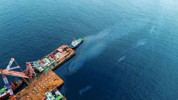
An oil spill is the accidental or intentional release of hydrocarbons into the environment, whether marine or terrestrial, caused by failures in platforms, pipelines, ships, or routine human activities. Even small events can devastate mangroves, affect coastal wildlife, degrade water quality, and cause damage that is evident for years.
Due to its magnitude and speed of dispersion, manual monitoring is inadequate: automated systems with remote sensing and sensors such as SAR are needed to speed up detection and reduce human error. Recent studies confirm that early identification significantly improves the effectiveness of environmental response, minimizes ecological damage, and reduces operating costs.
Spill detection algorithms: Advances with SAR
The accuracy of oil spill detection has improved dramatically thanks to specialized machine learning algorithms that analyze SAR images. These automated detection systems are key to processing the enormous amount of satellite data generated every day.
- DeepLabv3+ with local vs. generic data: A recent study, applied to the northern part of the Suez Canal, showed that training a DeepLabv3+ model with a local dataset is much more effective. This approach achieved 98.14% accuracy and a mIoU of 0.7872, clearly outperforming generic models. This highlights the importance of adapting models to specific geographic environments to optimize their performance.
- DAKD and SAROSS-Net, overcoming data scarcity: To mitigate the lack of labeled data, pipelines such as DAKD and models such as SAROSS-Net have been developed; these systems use data augmentation and distillation techniques to improve generalization, achieving better segmentation even with a limited dataset.
- LRA-UNet, improved attention and edges: The LRA-UNet model uses residual attention modules and an edge-sensitive loss function, enabling it to detect small oil spills, reduce false positives (caused by algae or calm seas), and preserve the actual shape of oil slicks in SAR images with complex backgrounds.
Global and public datasets for generalization
The availability of large-scale datasets is necessary to train robust and generalizable machine learning algorithms. These resources feed spill detection models with the diversity needed to operate anywhere in the world.
- GlobalOSD-SAR, robust large-scale detection: This massive dataset compiles over 100,000 images of oil slicks and look-alikes, taken from Sentinel-1 SAR. Covering 38 coastal regions, it offers unprecedented geographic diversity, allowing AI algorithms trained with this data to perform better in new areas.
- Specific datasets for complex environments: The “Oil Slicks, Look-Alikes and Remarkable SAR Signatures” dataset for the Eastern Mediterranean, which includes thousands of oil objects and similar phenomena, allows models to be trained to deal with the reality of false positives.
- LADOS, combining sensors for greater intelligence: The LADOS dataset integrates SAR and optical (RGB, near-infrared) images. This multimodal approach is key to understanding how to combine the strengths of both technologies, improving spill detection in coastal areas where visibility is critical.
The role of remote sensing and its sensors
Remote sensing is the primary basis for detecting oil spills. Data is captured using a variety of sensors mounted on satellites, aircraft, and drones, and then processed.
- Synthetic Aperture Radar (SAR): This is the primary sensor for spill detection; unlike optical sensors, SAR can operate day and night and through cloud cover. An oil spill dampens the roughness of the sea surface, reducing the backscatter of the radar signal. This creates a dark spot on the SAR image, allowing it to be identified. Dual or multiple polarization systems (VH-VV) offer unique signatures that help differentiate oil from other marine phenomena.
- Optical and infrared sensors: When light conditions permit, optical sensors in the visible, infrared (IR), and shortwave infrared (SWIR) bands are useful; hydrocarbons have unique spectral signatures that allow for their detection. Thermal imaging is especially useful, as the surface temperature of an oil spill may differ from that of the surrounding water.
Lightweight models and Edge Computing for immediate responses
Real-time oil spill detection requires efficient models that can operate on limited hardware without the need for a constant connection to the cloud. This is the core of edge computing.
- Tiny U-Net for drones: This model was optimized for drones, reducing its size by 269 times compared to the standard U-Net. Implemented on specialized low-power hardware (such as FPGAs), it allows the thickness of the oil film to be estimated directly on the aircraft. This dramatically reduces response time and enables immediate local monitoring.
- Full-Scale Aggregated MobileUNet: This lightweight and efficient model, designed for oil spill detection with SAR, requires less memory and is faster, facilitating higher inference frequency and, therefore, more continuous monitoring.
Real-world examples and detection in action
The theory comes to life with real-world examples. A notable case is the Deepwater Horizon oil spill in 2010; although automated detection was not as advanced at the time, today an event of that magnitude could be tracked with unprecedented accuracy and a rapid response system. Automated detection systems could have generated near-instant alerts, allowing emergency crews to contain the spill more efficiently.
- Study on the Suez Canal: The study using the DeepLabv3+ model on the Suez Canal demonstrates that models adapted to the local environment are superior for accurately estimating the spilled area, avoiding critical underestimations or overestimations that could affect the cleanup operation.
- Comparison of Datasets, LADOS vs. Sentinel-1: Studies using the LADOS dataset have confirmed that, although optical sensors offer high resolution, they are ineffective under cloud cover. SAR, on the other hand, maintains continuous coverage, making it indispensable for reliable oil spill detection.
The following video shows how satellites and AI help detect oil spills more quickly and with global coverage (Plymouth Marine Laboratory, 2024).
Benefits vs. real challenges
Despite technological advances, the implementation of these solutions in the field faces clear adversities.
- Clear advantages: The benefits are undeniable; automated detection allows for a faster response, which translates into less damage to marine ecosystems, a significant reduction in cleanup costs and fines, and more effective compliance with environmental regulations.
- Problems with false positives: Oil slicks can be confused with natural phenomena such as algae, calm areas of the sea, or even reflections from the sun. This generates false positives, which, although reduced with new datasets that include “look-alikes,” remain a problem in ensuring the reliability of the system.
- Environmental and temporal limitations: Adverse weather conditions such as strong winds, storms, or heavy cloud cover can complicate spill detection. In addition, satellite monitoring is limited by revisit times, meaning that a satellite does not always pass over the spill location at the precise moment it occurs; this can delay the initial response.
- Cost and infrastructure: The development and maintenance of complex AI models requires significant investment in high-performance computing infrastructure and, most importantly, in obtaining quality labeled data. This represents a barrier to entry for smaller organizations.
The future of oil spill detection
Innovations being discussed in the scientific community are paving the way for faster and more sustainable oil spill detection. Some of the key trends include:
- Hybrid models: The fusion of object detection with adaptive semantic segmentation will improve accuracy without requiring large amounts of labeled data.
- SAR satellite constellations: New constellations of small, multimodal SAR satellites will enable higher revisit frequency and advanced polarimetry.
- Improved spectroscopy: New hyperspectral sensors will make it possible to distinguish the type of contamination, emulsion, and chemical attributes of oil, not just its presence.
- Greater deployment at the edge: The use of specialized, low-power hardware in drones and mobile platforms will enable on-site alerts, reducing latency and improving response time.
- Standardization of datasets: Standardization of datasets and comparison metrics will facilitate operational adoption by government entities and companies.
Conclusions
The detection of oil spills using AI, SAR sensors, spectrometry, and satellite monitoring is advancing toward more accurate and agile systems. Models such as DAKD/SAROSS-Net, SAM-OIL, and Tiny U-Net show that it is possible to detect and segment spills quickly, reducing response time.
Although challenges remain, trends in edge computing, global datasets, and automated alerts promise a more proactive future in spill management. The innovations that will be discussed in upcoming technological innovation scenarios set the tone for protecting ecosystems, minimizing damage, and strengthening spill response.
References
- Automated oil spill detection using deep learning and SAR satellite data for the northern entrance of the Suez Canal, 2025 Jun 20. Consultado en https://pmc.ncbi.nlm.nih.gov/articles/PMC12181334/
- Data Augmentation and Knowledge Distillation using Diffusion Models for SAR Oil Spill Segmentation, 2024 Dec 11. Consultado en https://www.themoonlight.io/en/review/dakd-data-augmentation-and-knowledge-distillation-using-diffusion-models-for-sar-oil-spill-segmentation
- A Lightweight Residual Attention Network for SAR Marine Oil Spill Detection, 2025 Jun 12. Cosultado en https://www.mdpi.com/2077-1312/13/6/1161
- Oil Spill Drone: A Dataset of Drone-Captured, Segmented RGB Images for Oil Spill Detection in Port Environments, 2024 Feb 28. https://arxiv.org/html/2402.18202v1
Frequently Asked Questions (FAQs)
How is an oil spill detected by satellite?
Satellites primarily use Synthetic Aperture Radar (SAR) and optical sensors. SAR identifies oil slicks as dark areas because oil smooths out waves. Optical and infrared sensors can detect slicks by their color and unique spectral signature.
What is the most accurate method for detecting leaks?
There is no single method that is the most accurate; the most accurate detection is achieved by combining multiple technologies. SAR is ideal for initial and continuous detection due to its 24/7 capability. Optical or drone sensors can then provide additional details, such as estimating the thickness and type of hydrocarbon.
What are false positives in spill detection?
False positives occur when natural phenomena, such as areas of calm water (calm seas), biomass (algae), or low wind, are mistaken for spills. Modern machine learning algorithms are trained with datasets that include these look-alikes to improve accuracy and reduce errors.